On ice! Collecting data! Then, SNAFU, McGivering and change of plan...
A short post about a long day, so I can get some sleep before our early start tomorrow!
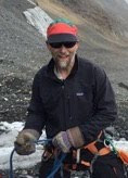
Today we got out on the ice for the first time this trip! The reason we came! It was a beautiful day. We met Daniel, our pilot, in the morning and loaded up the helicopter. We had a scenic flight to the ice, and when we arrived...
 |
| Photo: Adam LeWinter |
Long story short, we had a good day out, but by the end of it the laser scanner had encountered a "fatal error". After some discussion with the manufacturer, we think fatal may actually mean fatal, so we decided to change tactics for tomorrow:
We're going to go more old-school; instead of using the scanner, we will be collecting kinematic GPS data. This means we'll go out and walk, roped, along the transects on which we would have used the laser. To do this we needed to create a GPS antenna mount for the sleds we found...

We're looking forward to getting out there tomorrow.
posted by Bob @ 04:36
0 comments
![]()

0 Comments:
Post a Comment
<< Home