Tuesday, June 09, 2015

Headed Home!

Today we flew from Summit to Kangerlussuaq, on the coast- one stop from home.  It's been a whirlwind trip, with a lot of work and a lot of success!  Many thanks to all who had a hand in it- you probably know who you are. 

I wanted to end this season's postings with a parting shot of three out of the four-person crew of the 1997-1998 winter-over at Summit- by sheer luck we were reunited at Summit this week: Phil has been camp manager at Summit for the past 4 months, I arrived to do science, and then Pat drove in from East GRIP in a Case tractor.  It's been great to catch up with these guys, 18 years later!


From Left to Right: Me, Phil Austin, and Pat Smith.

Final day (we hope)- UAV success!

Today was (we think) our last chance to get a good survey of the station with our UAV.  After some fiddling with firmware, reprogramming the autopilot, and re-running all of the checks, we had a successful test flight- we were excited! 

Then we regrouped, got fresh batteries, mounted the camera, and relaunched- and had a very successful flight!  There are lots of good videos of launch and the parachute recovery, but they will have to wait until I get back to a faster connection. 

Here's the track of our UAV in Google Earth- we had great coverage of the camp with a single flight.


And an example of the aerial imagery we collected.  This is one of about 400 individual photos that make up the compilation- at home, we'll compile them and use Structure From Motion to generate a DEM!

fingers crossed for a flight tomorrow!

Monday, June 08, 2015

Sunday- some work with the UAV, and a field trip...

Today was Sunday, when the camp staff generally have a slow day or even a whole day off.  Routines are looser.  Since we are done with the GPS surveying, it's time to turn our attention to some of the other tasks we've brought with us.

One of them is the UAV- we're evaluating whether it will work up here at Summit- if so, we will use it to make a detailed topographic map of the camp and surrounding area; partly this will help out the camp management, who want to get a feel for how much snow (volume-wise) they will have to move away from buildings, but also there is a science goal- to learn about surface roughness, which is important for a number of reasons.


Here we are working on ground checks.  One of the aspects of operating a UAV is that there is a great deal of time spent fiddling with things on the ground and checking and re-checking them.  As it happened, there was a glitch in the altitude indicator, which prevented us from getting any flying in today.  This evening I updated the autopilot firmware, which fixed the glitch- so hopefully tomorrow will result in some flights.  There is still the altitude, so we are not certain to fly. 

The other thing we did today was to take a 'field trip' including some camp staff and other scientists, to a satellite camp about 10 km away, where investigators are drilling large ice cores to measure Carbon-14 in the ice. 

Here I'm driving the bus...

A good day all around, and looking forward to tomorrow!  Also, an aircraft update- there will be no flights tomorrow, as the C-130s in Kangerlussuaq are grounded.  They are flying some other planes from New York tomorrow, and that will hopefully allow us to fly out on schedule on Tuesday. 

Saturday, June 06, 2015

Last day of surveying!

Today we picked up our final three survey poles, but it was a pretty long drive; we went 36 km Eest to get across the ice divide, meaning we should see ice flowing to the East there.


After a long drive, we were ready for a snack- Joanna chose a frosty one...

Also out that direction is the last remaining evidence of a European drilling camp, populated in the late '80s and early '90s.  In its heyday, this camp had domes, tents, many structures, and a deep borehole that I've visited in years past


Now all that is exposed at the surface is the old HF radio antenna, which the camp used for communications with the outside world.  Times have changed and now the antenna above my head is a large dish that connects to a satellite- a different world indeed, that enables this blog post in fact!

The "interesting" news is that we were supposed to have a flight arrive today, but it was grounded with a mechanical issue- which apparently grounded the second plane in Kangerlussuaq as well- so flights are cancelled for tomorrow too.  With luck, we'll be able to fly out on Monday...  Fingers crossed!

Meanwhile, we'll try launching the UAV tomorrow, now that the GPS work is done.  Stay tuned!

More snowmobiling for science...

Today was another survey day, this time visiting 10 poles placed between 3 km and 18 km from Summit, and measuring the locations with geodetic-quality GPS.  It was a long day, but it means we're almost done with this (GPS survey) task. 
 The view you would have if you were my backseat passenger while we drive across the completely blank white canvas of the ice sheet.  Though it's all snow, there's an enormous variety of visual textures, so it doesn't really get boring. 


When we get to one of our poles (I almost tried to take a picture of what it looks like in the distance from about 500 meters away, but it would have been invisible!), we make sure it's still plumb using a rod level (this way we don't get some spurious movement simply from a tilting pole).


Then we mount our GPS antenna on the pole.  Depending on how far away from our base station (at summit) we are, we need to wait between 20 and 45 minutes in order to collect enough data to get a position with enough accuracy for our needs.  


What do we do while waiting?  Here, Joanna demonstrates the alternative decoding of the acronym "GPS": Great Places to Sleep!

 With luck, the weather plays along tomorrow and we have our last day of surveying.

Thursday, June 04, 2015

Skiing for Science!

Today our goal was to survey two poles that are in the clean air sector of Summit- this is a zone where no vehicle travel is allowed.  So we had to ski!  The two poles were 3 and 6 km from the main camp, but our route had to take us around the clean sector, so the whole route ended up being around 15 km. 

I started out towing the sled, heading to our two poles...

The survey occupations were actually a welcome respite from hauling the sled! 

Joanna took the sled on our return from the second pole- running the anchor leg!  It was pretty tiring as the sled was around 70 lbs, but both of us agreed (Joanna's reading "The Worst Journey in The World" by Apsley Cherry-Garrard, one of the men of Scott's 1911 expedition to the pole) that it wasn't so bad as they had it back in the early days...  Still neither of us is likely to take up man-hauling as a hobby any time soon!  I'm dog tired. 

Tomorrow- hopefully more surveying!


Wednesday, June 03, 2015

First day surveying!

Today we got ourselves ready, took cold weather gear, survival gear, survey gear, communications gear, and more gear than I can type, and took two snowmobiles and a survival sled out across the ice.  We surveyed 9 more of our stake locations, each occupation for between 15 and 30 minutes.  Between the wait time and the travel time between stakes, it added up to a long-ish day...
A typical stake. We pulled the survival sled up next to the stake, made sure it was plumb (not tilted, which could throw off the measurement) and placed our antenna.  Then it was time to wait 15-20 minutes.  If I were a napper, I'd have redone the GPS acronym to Great Places to Sleep. 

All in all, a very successful day!

Tuesday, June 02, 2015

Snowmobile training, traverse planning!

Today was another day of acclimatization, and getting ready for the work at hand.  While our GPS station continued to log away at our first site, getting better and better measurements with increased occupation time, we spent our time in training and planning. 

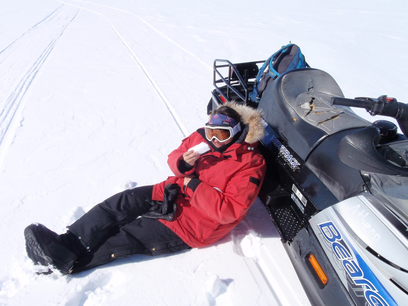
First, snowmobile training.  While I've been riding snowmobiles on ice sheets for almost 20 years now, there are always subtle differences with the machines from season to season, and getting the rundown on the machines from the mechanic responsible for their upkeep is always a valuable thing.  Also, not everyone has ridden a snowmobile before!
Joanna about to take her first snowmobile ride!

In addition to this, we spent a lot of time planning out where we plan to go (visiting the stakes that are arrayed around the station at distances of 3 to 36 km), so that the station crew here has our "flight plan" to which they can refer if we fail to check in on time.  Here's an excerpt from our plan:

** Full day plan 1:
   - depart summit 08:30
   - arrive C3N 08:45, begin 15 min occupation
   - depart C3N for C6N 09:10
   - arrive C6N 09:25, begin 15 min occupation
   - depart C6N 09:50 for FL3W
   - arrive FL3W 10:20, begin 15 min occupation
   - depart FL3W for FL6W 10:35
   - arrive FL6W 10:50, begin 15 min occupation
   - depart FL6W for FL9W 11:10
   - arrive FL9W 11:25, begin 20 minute occupation
   - depart FL9W for W6S 11:50
   - arrive W6S 12:20, begin 25 min occupation
   - depart W6S for W3S 12:55
   - arrive W3S 13:10, begin 25 min occupation
   - depart W3S for W0N 13:45
   - arrive W0N 14:00, begin 25 min occupation
   - depart W0N for W3N 14:35
   - arrive W3N 14:50, begin 25 min occupation
   - depart W3N for W6N 15:25
   - arrive W6N 15:40, begin 25 min occupation
   - depart W6N for Summit 16:15
   - arrive Summit 17:45

Now, it doesn't always go exactly according to our planned times, but it's important to have some estimates to see if what you plan is reasonable!  With luck tomorrow will be our first survey day...

Monday, June 01, 2015

Arrived at Summit, already collecting data!

One never knows, and I approached this morning's flight with a healthy dose of skepticism.  But our flight went off without a hitch, and we arrived at Summit in time for lunch!  I feel like that almost never happens. 

Flying from sea level to over 10,000 feet, I always feel a bit winded for the first day or so. And indeed, the camp manager, Phil (with whom I'd spent the winter here in 1997-1998), told all the new arrivals that the main job right now was to take it easy and get acclimatized. 

But we had some things we could do, in spite of the need to go slow.  Our first survey site is very close to the main camp, and so as soon as our gear arrived from the plane, we were able to take the short walk out to the site and get our GPS station mounted up. 

 Joanna, getting the GPS survey system ready.  It's powered by the small brick-like battery in the corner of the box.

 The system installed and logging.  This pole is right next to the casing for the GISP2 borehole, drilled years ago over 3000 meters to bedrock to collect an ice core record of past climate.  GISP2 is really the reason this camp is here at all.

Our primary goal on this trip is to make precise GPS survey measurements of the locations of a network of stakes, installed last year.  The motion of these stakes over the course of the year will tell us about how the ice sheet is moving in the region.  More on that tomorrow!